
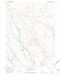
1965 Map of Knight
USGS Topo · Published 1967About this map
The Humboldt River winds through this high-desert basin, defining the corridor for both agriculture and transportation in the mid-1960s. The landscape is split between the flat, arid stretches of Pumpernickel Valley and the fertile riverbanks where White House Ranch and Ellison Ranch are established. This era shows the continued reliance on the transcontinental rail lines, with the Western Pacific and Southern Pacific railroads running parallel through the valley. Small railway-adjacent settlements like Red House, Knight, and Herrin represent the critical infrastructure of the Great Basin at this time. Water management is evident through features such as The Dike and a Footbridge over the river, while natural features like Alkali Flat and Herrin Slough illustrate the varying terrain between the river's path and the dry valley floor.
Find a feature on this map
17 named features on this map. Tap any name to fly to it.
Don’t see what you’re looking for? This feature index may not catch every label — zoom into the map to look around manually.
Map Details
Editions of this 1965 Knight Map
2 editions found
Other maps of this area

1882 · Paradise
USGS Topo · 1:250,000

1893 · Paradise
USGS Topo · 1:250,000

1932 · Sonoma Range
USGS Topo · 1:250,000

1939 · Sonoma Range
USGS Topo · 1:250,000

1945 · Osgood Mountains
USGS Topo · 1:62,500

1947 · Osgood Mountains
USGS Topo · 1:62,500

1955 · McDermitt
USGS Topo · 1:250,000

1955 · Winnemucca
USGS Topo · 1:250,000

1958 · Winnemucca
USGS Topo · 1:250,000

1959 · McDermitt
USGS Topo · 1:250,000