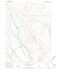
1965 Map of Knight
USGS Topo · Published 1981About this map
The Humboldt River winds through this Great Basin landscape, creating a fertile corridor for ranching and transport amidst the arid Pumpernickel Valley. During the mid-1960s, this area served as a critical junction for the region's heavy infrastructure, as the tracks of the Western Pacific and Southern Pacific railroads converge near the small station of Knight. The presence of established outposts like Red House, White House Ranch, and Ellison Ranch reflects a long-standing pattern of high-desert settlement centered on reliable water sources. A variety of smaller features provide clues to local activity and terrain, such as a Footbridge crossing the river, the marshy expanse of Herrin Slough near Herrin, and the prominent geological formation known as The Dike. These labels document a quiet, industry-linked landscape of Nevada's interior before modern interstate development fully transformed the corridor.
Find a feature on this map
18 named features on this map. Tap any name to fly to it.
Don’t see what you’re looking for? This feature index may not catch every label — zoom into the map to look around manually.
Map Details
Editions of this 1965 Knight Map
2 editions found

Other maps of this area

1882 · Paradise
USGS Topo · 1:250,000

1893 · Paradise
USGS Topo · 1:250,000

1932 · Sonoma Range
USGS Topo · 1:250,000

1939 · Sonoma Range
USGS Topo · 1:250,000

1945 · Osgood Mountains
USGS Topo · 1:62,500

1947 · Osgood Mountains
USGS Topo · 1:62,500

1955 · McDermitt
USGS Topo · 1:250,000

1955 · Winnemucca
USGS Topo · 1:250,000

1958 · Winnemucca
USGS Topo · 1:250,000

1959 · McDermitt
USGS Topo · 1:250,000