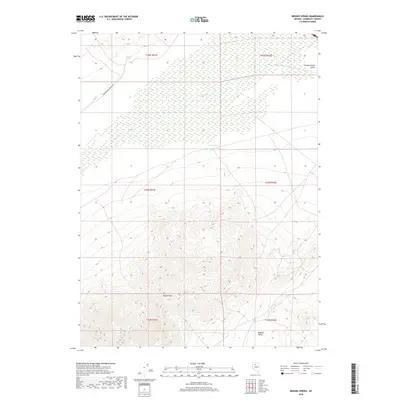
2018 Map of Brooks Spring
USGS Topo · Published 2018About this map
Buffalo Mtn dominates the southern half of this quadrangle, rising sharply above the desert floor of north-central Nevada. The landscape is defined by the high desert basins of Pumpernickel Valley to the north and Buffalo Valley to the south, separated by this significant mountain mass. This 2018 survey illustrates a remote landscape where water sources like Brooks Spring and Sulphur Spring serve as critical landmarks in an otherwise arid environment. Along the western edge, Pumpernickel Valley Rd follows the base of the mountains, tracing the traditional path of travel through these Great Basin corridors. The map also captures the seasonal flow of Ragan Cr, illustrating the intricate drainage patterns that characterize the transition between these high peaks and the surrounding valley floors.
Find a feature on this map
13 named features on this map. Tap any name to fly to it.
Don’t see what you’re looking for? This feature index may not catch every label — zoom into the map to look around manually.
Map Details
Editions of this 2018 Brooks Spring Map
This is the sole edition of this map. No revisions or reprints were ever made.
Other maps of this area

1932 · Sonoma Range
USGS Topo · 1:250,000

1939 · Sonoma Range
USGS Topo · 1:250,000

1940 · Antler Peak
USGS Topo · 1:62,500

1943 · Antler Peak
USGS Topo · 1:62,500

1955 · Winnemucca
USGS Topo · 1:250,000

1958 · Winnemucca
USGS Topo · 1:250,000

1962 · Winnemucca
USGS Topo · 1:250,000

1965 · Knight
USGS Topo · 1:24,000

1965 · Goldrun Creek
USGS Topo · 1:24,000
1965 · Golconda
USGS Topo · 1:24,000