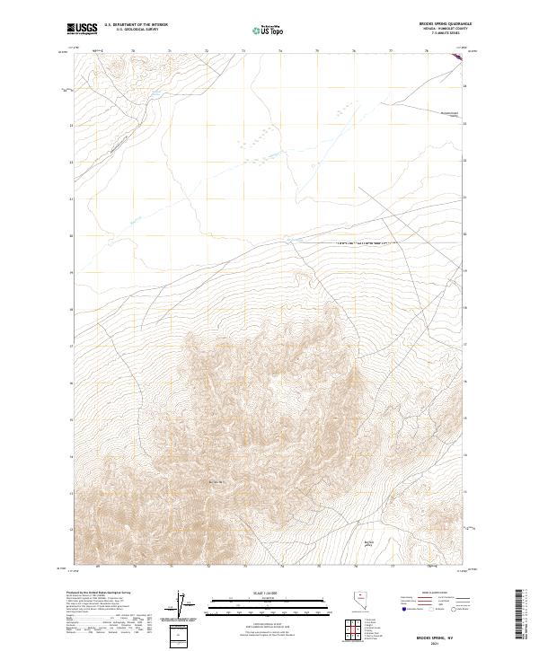
2021 Map of Brooks Spring
USGS Topo · Published 2021About this map
Buffalo Mtn dominates the southern reaches of this landscape, its contours defining a massive landform that separates two distinct lowlands in Humboldt County. To the north lies Pumpernickel Valley, a broad expanse accessed by Pumpernickel Valley Rd and drained by the intermittent Ragan Cr. The transition between the high peaks and the valley floor is punctuated by vital water sources such as Sulphur Spring and Brooks Spring, which historically served as critical landmarks in this arid environment. To the southeast, the terrain opens into Buffalo Valley, illustrating the classic basin-and-range topography. The map detail highlights the sparse settlement patterns typical of this region, where the naming of individual springs and peaks serves as the primary coordinate system for navigation and land use.
Find a feature on this map
14 named features on this map. Tap any name to fly to it.
Don’t see what you’re looking for? This feature index may not catch every label — zoom into the map to look around manually.
Map Details
Editions of this 2021 Brooks Spring Map
This is the sole edition of this map. No revisions or reprints were ever made.
Other maps of this area

1932 · Sonoma Range
USGS Topo · 1:250,000

1939 · Sonoma Range
USGS Topo · 1:250,000

1940 · Antler Peak
USGS Topo · 1:62,500

1943 · Antler Peak
USGS Topo · 1:62,500

1955 · Winnemucca
USGS Topo · 1:250,000

1958 · Winnemucca
USGS Topo · 1:250,000

1962 · Winnemucca
USGS Topo · 1:250,000

1965 · Knight
USGS Topo · 1:24,000

1965 · Goldrun Creek
USGS Topo · 1:24,000
1965 · Golconda
USGS Topo · 1:24,000