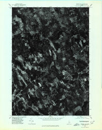
1975 Map of Brooks SW
USGS Topo · Published 1980About this map
Jackson Corners and the surrounding Waldo County landscape are captured in this orthophotograph, which utilizes aerial imagery taken in late October 1975. This specialized format emphasizes the actual land use and vegetation patterns of the era, showing a mosaic of woodlots and cleared agricultural fields connected by a network of rural roads. Several historically significant crossroads are documented, including Knox Center, Ray Corner, and East Knox. The drainage of the region is anchored by the southern reaches of Lake Passagassawakeag and the winding course of Marsh Stream. Unlike traditional line maps, this imagery provides a literal view of the homesteads and clearings at Knox Lodge Corner, offering genealogists and local historians a precise look at the mid-1970s Maine countryside.
Find a feature on this map
7 named features on this map. Tap any name to fly to it.
Don’t see what you’re looking for? This feature index may not catch every label — zoom into the map to look around manually.
Map Details
Editions of this 1975 Brooks SW Map
This is the sole edition of this map. No revisions or reprints were ever made.
Other maps of this area

1915 · Belfast
USGS Topo · 1:62,500

1916 · Liberty
USGS Topo · 1:62,500

1917 · Belfast
USGS Topo · 1:62,500

1926 · Burnham
USGS Topo · 1:62,500

1932 · Brooks
USGS Topo · 1:62,500

1941 · Belfast
USGS Topo · 1:62,500

1942 · Liberty
USGS Topo · 1:62,500

1948 · Bangor
USGS Topo · 1:250,000

1950 · Belfast
USGS Topo · 1:50,000

1950 · Liberty
USGS Topo · 1:50,000