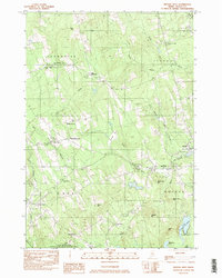
1982 Map of Brooks West
USGS Topo · Published 1983About this map
Belfast and Moosehead Lake railroad tracks define the rural transportation corridor through these Waldo County towns in the early 1980s. The landscape is dotted with several historic crossroads and former railroad stops, including Knox Station and Knox Ledge Corner. The map captures a detailed inventory of local family and community history, recording numerous burial grounds such as Cole Cem and Styles Cem, alongside landmarks like the Center Ch and the Church of God.
Find a feature on this map
51 named features on this map. Tap any name to fly to it.
Don’t see what you’re looking for? This feature index may not catch every label — zoom into the map to look around manually.
Map Details
Editions of this 1982 Brooks West Map
This is the sole edition of this map. No revisions or reprints were ever made.
Other maps of this area

1915 · Belfast
USGS Topo · 1:62,500

1916 · Liberty
USGS Topo · 1:62,500

1917 · Belfast
USGS Topo · 1:62,500

1926 · Burnham
USGS Topo · 1:62,500

1932 · Brooks
USGS Topo · 1:62,500

1941 · Belfast
USGS Topo · 1:62,500

1942 · Liberty
USGS Topo · 1:62,500

1948 · Bangor
USGS Topo · 1:250,000

1950 · Belfast
USGS Topo · 1:50,000

1950 · Liberty
USGS Topo · 1:50,000