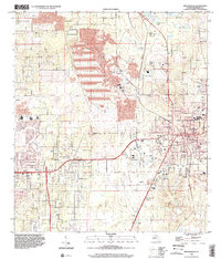
1998 Map of Brooksville
USGS Topo · Published 2002About this map
Brooksville serves as the focal point of this late-century Hernando County survey, showing a landscape defined by significant industrial modification and residential expansion. Large Tailings Ponds and the settlement of Camps highlight the area's history of extractive industry, while the rising suburban layout of Spring Hill and Wiscon indicates the region's mid-to-late 20th-century growth. Educational infrastructure is densely mapped, featuring Hernando HS, Central HS, and Delores S. Parrott Sch. The terrain varies from the elevations of Barkley Hill to the wetland basins of Horse Lake, Simmons Prairie Lake, and Willow Prairie Lake, providing a clear look at the hydraulic character of the Florida peninsula before further development changed these natural water levels. Historic rail and road connections are preserved at sites like Tooke Lake Junction, documenting the transition from a resource-based economy to a modern residential hub.
Find a feature on this map
21 named features on this map. Tap any name to fly to it.
Don’t see what you’re looking for? This feature index may not catch every label — zoom into the map to look around manually.
Map Details
Editions of this 1998 Brooksville Map
This is the sole edition of this map. No revisions or reprints were ever made.
Other maps of this area

1954 · Spring Lake
USGS Topo · 1:24,000

1954 · Brooksville NW
USGS Topo · 1:24,000

1954 · Nobleton
USGS Topo · 1:24,000

1954 · Brooksville
USGS Topo · 1:24,000

1954 · Chassahowitzka
USGS Topo · 1:24,000

1954 · Masaryktown
USGS Topo · 1:24,000

1954 · Brooksville SE
USGS Topo · 1:24,000

1954 · Weekiwachee Springs
USGS Topo · 1:24,000

1954 · Port Richey NE
USGS Topo · 1:24,000

1955 · Plant City
USGS Topo · 1:250,000