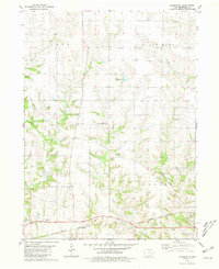
1980 Map of Brookville
USGS Topo · Published 1981About this map
Brookville serves as a central hub for this rural Jefferson County landscape, where the agricultural grid is intersected by the winding paths of Cedar Creek, Competine Creek, and South Walnut Creek. The southern edge of the map is defined by the Burlington Northern railroad corridor, a vital link for the region's farming economy. The presence of several family-named burial grounds, including Myers Cem, Brooks Cem, and Gregg Cem, points to the long-established lineage of local farming families. The map also records specialized aviation and communication infrastructure such as the Middlekoop Landing Strip and a Radio Tower (KMCD), reflecting the modernization of this traditional Iowa countryside during the late twentieth century.
Find a feature on this map
22 named features on this map. Tap any name to fly to it.
Don’t see what you’re looking for? This feature index may not catch every label — zoom into the map to look around manually.
Map Details
Editions of this 1980 Brookville Map
This is the sole edition of this map. No revisions or reprints were ever made.
Other maps of this area

1954 · Centerville
USGS Topo · 1:250,000

1954 · Des Moines
USGS Topo · 1:250,000

1956 · Des Moines
USGS Topo · 1:250,000

1957 · Des Moines
USGS Topo · 1:250,000

1957 · Centerville
USGS Topo · 1:250,000

1958 · Centerville
USGS Topo · 1:250,000

1958 · Burlington
USGS Topo · 1:250,000

1958 · Davenport
USGS Topo · 1:250,000

1961 · Burlington
USGS Topo · 1:250,000

1961 · Davenport
USGS Topo · 1:250,000