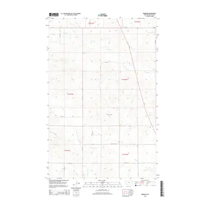
2014 Map of Brorson
USGS Topo · Published 2014About this map
Brorson (Historical) centers this topographic study of the Montana plains, situated along the intersection of CR-344 and CR-129. The landscape is defined by the complex drainage systems of the Missouri River plateau, notably where Main Hay Cr and the various branches of First Hay Cr carve through the terrain. Evidence of the region's carbon-based economy is visible at the Brorson Oil Field, which occupies a significant portion of the central township.
Find a feature on this map
25 named features on this map. Tap any name to fly to it.
Don’t see what you’re looking for? This feature index may not catch every label — zoom into the map to look around manually.
Map Details
Editions of this 2014 Brorson Map
This is the sole edition of this map. No revisions or reprints were ever made.
Other maps of this area

1909 · Glendive
USGS Topo · 1:250,000

1954 · Glendive
USGS Topo · 1:250,000

1957 · Glendive
USGS Topo · 1:250,000

1958 · Glendive
USGS Topo · 1:250,000

1966 · Crane NE
USGS Topo · 1:24,000

1966 · Crane NW
USGS Topo · 1:24,000

1966 · Sidney
USGS Topo · 1:24,000

1972 · Brorson
USGS Topo · 1:24,000

1972 · Girard
USGS Topo · 1:24,000
1972 · Fairview NW
USGS Topo · 1:24,000