
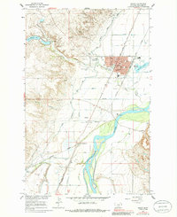
1966 Map of Sidney
USGS Topo · Published 1971About this map
Sidney serves as the focal point of this mid-1960s landscape, positioned where the Northern Pacific and Great Northern rail lines converge near the Yellowstone River. The town's social and civic structure is documented through its concentration of local landmarks, including the Courthouse, St Philomena Sch, and several recreational spaces like Nutter Memorial Park. This era shows a community in transition, with traditional infrastructure like the Main Canal for irrigation operating alongside modern developments like the Drive-in Theater and Sidney-Richland Airport.
Find a feature on this map
44 named features on this map. Tap any name to fly to it.
Don’t see what you’re looking for? This feature index may not catch every label — zoom into the map to look around manually.
Map Details
Editions of this 1966 Sidney Map
2 editions found
Other maps of this area

1909 · Glendive
USGS Topo · 1:250,000

1954 · Glendive
USGS Topo · 1:250,000

1957 · Glendive
USGS Topo · 1:250,000

1958 · Glendive
USGS Topo · 1:250,000

1966 · Crane NE
USGS Topo · 1:24,000

1966 · Piche
USGS Topo · 1:24,000

1966 · Crane
USGS Topo · 1:24,000

1966 · Sidney NE
USGS Topo · 1:24,000

1972 · Brorson
USGS Topo · 1:24,000
1972 · Fairview
USGS Topo · 1:24,000