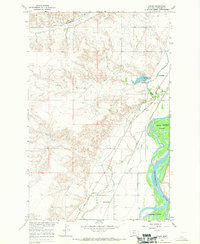
1966 Map of Crane
USGS Topo · Published 1970About this map
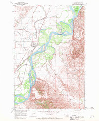
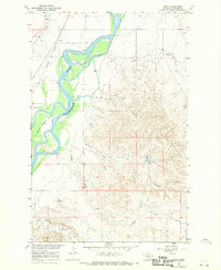
The Yellowstone River dominates the eastern edge of this landscape, its braided channels weaving around Seven Sisters Island and Crittenden Island. This 1966 field-checked survey reveals an intricate irrigation and transport network vital to the Richland County river valley, including the Main Canal and a curious Elevated Canal near the town of Crane. The historic Lewis and Clark Trail follows the river's path, cutting through the terrain alongside the Great Northern railroad tracks.
Find a feature on this map
21 named features on this map. Tap any name to fly to it.
Don’t see what you’re looking for? This feature index may not catch every label — zoom into the map to look around manually.
Map Details
Editions of this 1966 Crane Map
This is the sole edition of this map. No revisions or reprints were ever made.
Other maps of this area

1909 · Glendive
USGS Topo · 1:250,000

1954 · Glendive
USGS Topo · 1:250,000

1957 · Glendive
USGS Topo · 1:250,000

1958 · Glendive
USGS Topo · 1:250,000
1966 · Savage
USGS Topo · 1:24,000
1966 · Crane NE
USGS Topo · 1:24,000
1966 · Crane NW
USGS Topo · 1:24,000
1966 · Piche
USGS Topo · 1:24,000
1966 · Knife River Mine
USGS Topo · 1:24,000
1966 · Skaar NW
USGS Topo · 1:24,000