
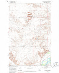
1966 Map of Knife River Mine
USGS Topo · Published 1970About this map
The Knife River Mine and extensive Strip Mines dominate the northern landscape of this Richland County survey, illustrating the industrial footprint of lignite mining in eastern Montana. Just south of the active excavations, the small settlement of Peabody sits along the Northern Pacific railroad line, which follows the drainage of Peabody Coulee. The terrain is characterized by a series of deep drainages including Garden Coulee and Beef Slough that cut through the breaks toward the river valley below.
Find a feature on this map
18 named features on this map. Tap any name to fly to it.
Don’t see what you’re looking for? This feature index may not catch every label — zoom into the map to look around manually.
Map Details
Editions of this 1966 Knife River Mine Map
2 editions found
Other maps of this area

1909 · Glendive
USGS Topo · 1:250,000

1954 · Glendive
USGS Topo · 1:250,000

1957 · Glendive
USGS Topo · 1:250,000

1958 · Glendive
USGS Topo · 1:250,000

1966 · Savage
USGS Topo · 1:24,000

1966 · Savage SE
USGS Topo · 1:24,000

1966 · Savage SW
USGS Topo · 1:24,000

1966 · Intake
USGS Topo · 1:24,000

1966 · Crane
USGS Topo · 1:24,000

1966 · Allard Ranch
USGS Topo · 1:24,000