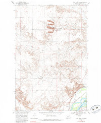
1966 Map of Knife River Mine
USGS Topo · Published 1984About this map
Industrial excavations at the Knife River Mine dominate the high ground of Richland County in the mid-1960s, showing a series of active Strip Mines north of Peabody Coulee. This landscape is defined by the sharp contrast between the upland mining operations and the riparian activity along the Yellowstone River in the southeast. Near the riverbanks, the Northern Pacific railroad tracks parallel the Lewis and Clark Canal, supporting the regional movement of resources. Small settlements like Valentine and Flat are positioned near the river, while a Pumping Sta and various wells indicate the infrastructure required for water management and resource extraction. The terrain is deeply incised by drainages such as Garden Coulee and Beef Slough, which navigate the complex topography surrounding Marys Island.
Find a feature on this map
19 named features on this map. Tap any name to fly to it.
Don’t see what you’re looking for? This feature index may not catch every label — zoom into the map to look around manually.
Map Details
Editions of this 1966 Knife River Mine Map
2 editions found
Other maps of this area

1909 · Glendive
USGS Topo · 1:250,000

1954 · Glendive
USGS Topo · 1:250,000

1957 · Glendive
USGS Topo · 1:250,000

1958 · Glendive
USGS Topo · 1:250,000

1966 · Savage
USGS Topo · 1:24,000

1966 · Savage SE
USGS Topo · 1:24,000

1966 · Savage SW
USGS Topo · 1:24,000

1966 · Intake
USGS Topo · 1:24,000

1966 · Knife River Mine
USGS Topo · 1:24,000

1966 · Crane
USGS Topo · 1:24,000