1972 Map of Fairview
USGS Topo · Published 1975About this map
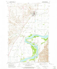
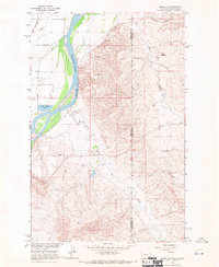
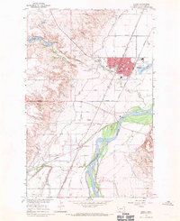
Fairview and East Fairview straddle the border of Montana and North Dakota, serving as a dual-state hub in the Yellowstone Valley during the early 1970s. The landscape is defined by the sweeping curves of the Yellowstone River and a complex network of irrigation canals and laterals that support the region's agriculture. The Burlington Northern railroad cuts a diagonal path through the valley, connecting outlying points like Ludington and Ridgelawn to the central settlements. Evidence of early local history is found in several rural burial grounds, including Pioneer Cem north of town and Bethel Cem to the south. The area’s development is further marked by the presence of a Landing Strip and the Radio Towers (KGCX), reflecting the infrastructure of a mid-century river community. Small rural institutions such as Estes Sch near the riverbank highlight the dispersed nature of the original homestead settlements.
Find a feature on this map
28 named features on this map. Tap any name to fly to it.
Don’t see what you’re looking for? This feature index may not catch every label — zoom into the map to look around manually.
Map Details
Editions of this 1972 Fairview Map
This is the sole edition of this map. No revisions or reprints were ever made.
Other maps of this area

1909 · Glendive
USGS Topo · 1:250,000

1953 · Watford City
USGS Topo · 1:250,000

1954 · Glendive
USGS Topo · 1:250,000

1957 · Glendive
USGS Topo · 1:250,000

1957 · Watford City
USGS Topo · 1:250,000

1958 · Glendive
USGS Topo · 1:250,000
1966 · Sidney NE
USGS Topo · 1:24,000
1966 · Sidney
USGS Topo · 1:24,000

1967 · Watford City
USGS Topo · 1:250,000

1968 · Buford
USGS Topo · 1:24,000