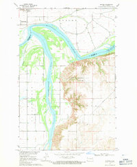
1968 Map of Buford
USGS Topo · Published 1971About this map
The confluence of the Yellowstone River and the Missouri River dominates this late 1960s survey, marking a vital hydrographic junction on the North Dakota-Montana border. This landscape is steeped in frontier history at the Fort Buford State Historic Site, located just west of the small settlement of Buford. The terrain transitions from the broad river bottomlands to the eroded breaks of the Sioux region to the south. Modern infrastructure is represented by the Burlington Northern railroad corridor and a pipeline cutting across the eastern bluffs. To the east, the rising waters of Lake Sakakawea begin to take shape, with certain areas marked as subject to controlled inundation. Localized details like a siphon on Fourmile Creek and a drill hole in the southern hills reflect the agricultural and industrial activities of the era.
Find a feature on this map
14 named features on this map. Tap any name to fly to it.
Don’t see what you’re looking for? This feature index may not catch every label — zoom into the map to look around manually.
Map Details
Editions of this 1968 Buford Map
2 editions found
Other maps of this area

1909 · Glendive
USGS Topo · 1:250,000

1953 · Williston
USGS Topo · 1:250,000

1953 · Watford City
USGS Topo · 1:250,000

1954 · Glendive
USGS Topo · 1:250,000

1954 · Wolf Point
USGS Topo · 1:250,000

1957 · Glendive
USGS Topo · 1:250,000

1957 · Williston
USGS Topo · 1:250,000

1957 · Watford City
USGS Topo · 1:250,000

1958 · Wolf Point
USGS Topo · 1:250,000

1958 · Glendive
USGS Topo · 1:250,000