
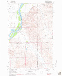
1966 Map of Sidney NE
USGS Topo · Published 1970About this map
The Yellowstone River cuts through this borderlands landscape, defining the boundary between Montana and North Dakota during the mid-1960s. Along its western bank, the Great Northern railroad tracks run parallel to the water, supporting the regional transport of goods and passengers. The eastern side of the river transitions into a highly dissected upland terrain marked by numerous drainage systems, including Cheney Creek and Alkali Creek.
Find a feature on this map
21 named features on this map. Tap any name to fly to it.
Don’t see what you’re looking for? This feature index may not catch every label — zoom into the map to look around manually.
Map Details
Editions of this 1966 Sidney NE Map
2 editions found
Other maps of this area

1909 · Glendive
USGS Topo · 1:250,000

1953 · Watford City
USGS Topo · 1:250,000

1954 · Glendive
USGS Topo · 1:250,000

1957 · Glendive
USGS Topo · 1:250,000

1957 · Watford City
USGS Topo · 1:250,000

1958 · Glendive
USGS Topo · 1:250,000

1966 · Piche
USGS Topo · 1:24,000

1966 · Sidney
USGS Topo · 1:24,000

1967 · Watford City
USGS Topo · 1:250,000

1972 · Horse Creek School
USGS Topo · 1:24,000