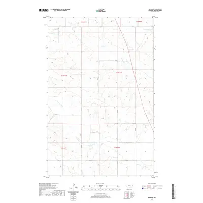
2020 Map of Brorson
USGS Topo · Published 2020About this map
Brorson Creek defines the southern drainage of this Montana landscape, where the high plains of Richland County meet a complex network of intermittent watercourses. This modern survey illustrates the enduring Public Land Survey System boundaries, including Township 24 North, Range 58 East, which organize the vast agricultural and grazing lands of the region. The map reveals the critical importance of drainage in this semi-arid environment, tracing the paths of Main Hay Creek and First Hay Creek as they cut through the terrain. A grid of section roads, such as County Road 129 and County Road 344, provides the primary infrastructure for accessing the remote homesteads and ranching operations that characterize the local economy in the twenty-first century. The intersection of these drainage patterns and road systems offers a clear picture of how the landscape is managed and navigated today.
Find a feature on this map
20 named features on this map. Tap any name to fly to it.
Don’t see what you’re looking for? This feature index may not catch every label — zoom into the map to look around manually.
Map Details
Editions of this 2020 Brorson Map
This is the sole edition of this map. No revisions or reprints were ever made.
Other maps of this area

1909 · Glendive
USGS Topo · 1:250,000

1954 · Glendive
USGS Topo · 1:250,000

1957 · Glendive
USGS Topo · 1:250,000

1958 · Glendive
USGS Topo · 1:250,000

1966 · Crane NE
USGS Topo · 1:24,000

1966 · Crane NW
USGS Topo · 1:24,000

1966 · Sidney
USGS Topo · 1:24,000

1972 · Brorson
USGS Topo · 1:24,000

1972 · Girard
USGS Topo · 1:24,000
1972 · Fairview NW
USGS Topo · 1:24,000