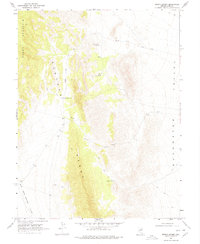
1968 Map of Brown Summit
USGS Topo · Published 1978About this map
Pancake Range dominates this central Nevada terrain, standing as a high ridge between the Big Sand Springs Valley to the west and Duckwater Valley to the east. This late 1960s survey documents a landscape defined by isolation and essential water sources, centered on the Brown Summit pass. Small signs of human occupancy and livestock management appear in the form of the Florio Outrider Cabin and the Brown Summit Truck Trail, which provided rugged access through these mountains. Vital water points such as Young Florio Spring and McClure Spring are carefully noted, anchoring the local geography for ranchers and travelers. The mapping of Moody Mountain and various benchmark locations highlights the survey's focus on precise topographic control in a region where land lines had not yet been established.
Find a feature on this map
23 named features on this map. Tap any name to fly to it.
Don’t see what you’re looking for? This feature index may not catch every label — zoom into the map to look around manually.
Map Details
Editions of this 1968 Brown Summit Map
2 editions found
Other maps of this area

1951 · Green Springs
USGS Topo · 1:62,500

1956 · Lund
USGS Topo · 1:250,000

1956 · Ely
USGS Topo · 1:250,000

1959 · Ely
USGS Topo · 1:250,000

1960 · Lund
USGS Topo · 1:250,000

1963 · Ely
USGS Topo · 1:250,000

1964 · Duckwater
USGS Topo · 1:62,500

1964 · Moody Peak
USGS Topo · 1:62,500

1968 · Brown Summit
USGS Topo · 1:24,000
1968 · Brown Summit NW
USGS Topo · 1:24,000