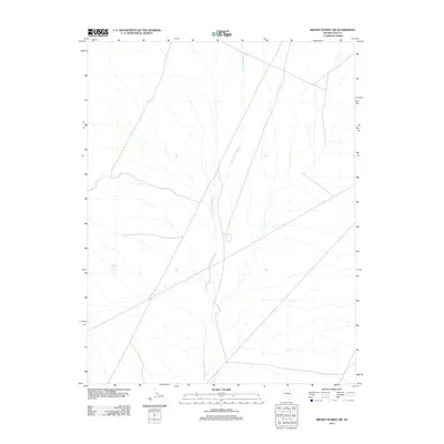
2012 Map of Brown Summit SW
USGS Topo · Published 2012About this map
Sand Springs Wash defines the drainage patterns across this arid landscape in Nye County, following a southwesterly course that organizes the local desert topography. This 2012 survey by the U. S. Geological Survey provides a precise view of the water resources that have historically dictated human and animal activity in the region. Near the western edge of the quadrangle, White Rock Spring represents a critical hydrological point in an otherwise dry expanse. The map is characterized by a network of unimproved roads and 4WD tracks, indicating a landscape utilized for ranching, exploration, or mineral assessment. The lack of formal settlements highlights the isolation of this high desert terrain, where named features are limited primarily to these vital water sources and the natural contours they have shaped over time.
Find a feature on this map
2 named features on this map. Tap any name to fly to it.
Don’t see what you’re looking for? This feature index may not catch every label — zoom into the map to look around manually.
Map Details
Editions of this 2012 Brown Summit SW Map
This is the sole edition of this map. No revisions or reprints were ever made.
Other maps of this area

1956 · Lund
USGS Topo · 1:250,000

1956 · Tonopah
USGS Topo · 1:250,000

1959 · Tonopah
USGS Topo · 1:250,000

1960 · Lund
USGS Topo · 1:250,000

1962 · Tonopah
USGS Topo · 1:250,000

1967 · Moores Station
USGS Topo · 1:62,500

1967 · Chaos Creek
USGS Topo · 1:24,000

1968 · Portuguese Mtn
USGS Topo · 1:62,500

1968 · Brown Summit
USGS Topo · 1:24,000
1968 · Brown Summit NW
USGS Topo · 1:24,000