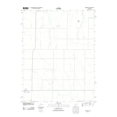
2012 Map of Brownell
USGS Topo · Published 2012About this map
Brownell anchors the southwestern corner of this West-Central Kansas landscape, centered on a small grid that includes the local Po at the intersection of Main St and 6th St. This area reflects the sparse, rhythmic layout of high-plains agriculture, where a network of county roads like Co Rd 565 and N BB Rd connects isolated farmsteads across wide-open sections. The drainage patterns of Big Timber Cr and Tunnel Cr create the primary relief in the terrain, carving subtle draws across the prairie. A notable landmark in the northern reaches is Round House Rock, a distinctive physical feature that breaks the horizon in an otherwise uniformly surveyed grid. This 2012 survey captures the community and its infrastructure before recent changes in rural land use and rural post office consolidations.
Find a feature on this map
10 named features on this map. Tap any name to fly to it.
Don’t see what you’re looking for? This feature index may not catch every label — zoom into the map to look around manually.
Map Details
Editions of this 2012 Brownell Map
This is the sole edition of this map. No revisions or reprints were ever made.
Other maps of this area

1893 · Ellis
USGS Topo · 1:125,000

1955 · Great Bend
USGS Topo · 1:250,000

1957 · Great Bend
USGS Topo · 1:250,000

1958 · Great Bend
USGS Topo · 1:250,000

1965 · Mc Cracken
USGS Topo · 1:24,000

1966 · Ransom SE
USGS Topo · 1:24,000

1966 · Mc Cracken SW
USGS Topo · 1:24,000
1974 · Cedar Bluff Dam
USGS Topo · 1:24,000
1974 · Cedar Bluff
USGS Topo · 1:24,000
1974 · Ellis SE
USGS Topo · 1:24,000