
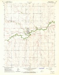
1966 Map of Ransom SE
USGS Topo · Published 1967About this map
Bazine Dry Creek and Long Creek carve the upland plains of Ness County in this mid-1960s topographic record. The landscape is defined by the intersections of several townships, including Nevada, Waring, Center, and Bazine. The map highlights a rural environment where land use is dominated by agriculture and natural resource extraction. Notable for genealogists is the Brownell Cem located in the northern reaches, while several industrial markers like a lone Oil Well and scattered Sandpit sites indicate the local economic activity during this era. The detailed contour intervals reveal the subtle drainage patterns that define this section of the Kansas prairie before modern intensive development altered the rural footprint.
Find a feature on this map
9 named features on this map. Tap any name to fly to it.
Don’t see what you’re looking for? This feature index may not catch every label — zoom into the map to look around manually.
Map Details
Editions of this 1966 Ransom SE Map
This is the sole edition of this map. No revisions or reprints were ever made.
Other maps of this area

1892 · Ness
USGS Topo · 1:125,000

1893 · Ellis
USGS Topo · 1:125,000

1894 · Ness
USGS Topo · 1:125,000

1955 · Great Bend
USGS Topo · 1:250,000

1957 · Great Bend
USGS Topo · 1:250,000

1958 · Great Bend
USGS Topo · 1:250,000

1966 · Mc Cracken SW
USGS Topo · 1:24,000

1966 · Ness City
USGS Topo · 1:24,000

1966 · Ness City NE
USGS Topo · 1:24,000
1966 · Bazine
USGS Topo · 1:24,000