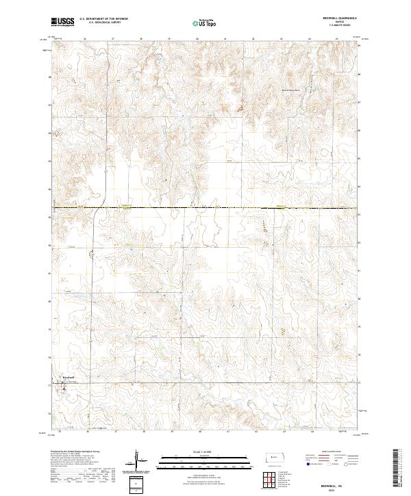
2022 Map of Brownell
USGS Topo · Published 2022About this map
Brownell stands as the primary settlement in this section of Ness County, situated at the intersection of Davis Ave and several rural county routes. The landscape transitions from the flat upland plains into the dissected drainage basins of Big Timber Cr and Tunnel Cr. These watercourses have carved distinct local landmarks into the terrain, including the prominent Round House Rock and the narrow corridor of Goat Canyon along the western edge. The map also detail the Trego County and Ness County boundary line, illustrating the rigid grid of the Public Land Survey System that governs the placement of roads like Co Rd 565 and Dd Rd. This 2022 survey captures the contemporary rural character of the High Plains, where agricultural land use is punctuated by natural features like Wildon Draw.
Find a feature on this map
29 named features on this map. Tap any name to fly to it.
Don’t see what you’re looking for? This feature index may not catch every label — zoom into the map to look around manually.
Map Details
Editions of this 2022 Brownell Map
This is the sole edition of this map. No revisions or reprints were ever made.
Other maps of this area

1893 · Ellis
USGS Topo · 1:125,000

1955 · Great Bend
USGS Topo · 1:250,000

1957 · Great Bend
USGS Topo · 1:250,000

1958 · Great Bend
USGS Topo · 1:250,000

1965 · Mc Cracken
USGS Topo · 1:24,000

1966 · Ransom SE
USGS Topo · 1:24,000

1966 · Mc Cracken SW
USGS Topo · 1:24,000
1974 · Cedar Bluff Dam
USGS Topo · 1:24,000
1974 · Cedar Bluff
USGS Topo · 1:24,000
1974 · Ellis SE
USGS Topo · 1:24,000