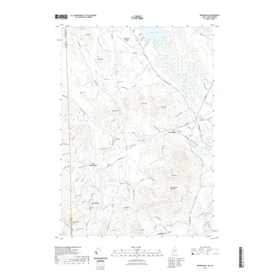
2021 Map of Brownfield
USGS Topo · Published 2021About this map
Brownfield and West Brownfield anchor this portion of Oxford County, Maine, sitting at the junction of river valleys and the Burnt Meadow Mountains. The landscape is defined by the winding course of the Saco River and its numerous tributaries, including the Little Saco River and Shepards River. For local historians and genealogists, the map provides an exceptional density of family-named burial grounds, such as Marston Cem, Wentworth - Brown Cem, and Walker - Rounds Cem. These sites, along with settlements like New Boston and Porterfield, offer a clear picture of the historical distribution of community life across the region. Aviation infrastructure is represented by the Eastern Slopes Regional Airport in the north, while the southern terrain rises steeply toward peaks like Frost Mtn and Stone Mtn. The detailed hydrography traces many brooks, including Linscott Brook and Quint Brook, which drain the varied topography of this Maine-New Hampshire borderland.
Find a feature on this map
108 named features on this map. Tap any name to fly to it.
Don’t see what you’re looking for? This feature index may not catch every label — zoom into the map to look around manually.
Map Details
Editions of this 2021 Brownfield Map
This is the sole edition of this map. No revisions or reprints were ever made.
Other maps of this area

1894 · North Conway
USGS Topo · 1:62,500

1896 · North Conway
USGS Topo · 1:62,500

1909 · Fryeburg
USGS Topo · 1:62,500

1910 · Kezar Falls
USGS Topo · 1:48,000

1911 · Fryeburg
USGS Topo · 1:62,500

1911 · Kezar Falls
USGS Topo · 1:62,500

1930 · Ossipee Lake
USGS Topo · 1:62,500

1941 · Fryeburg
USGS Topo · 1:62,500

1942 · North Conway
USGS Topo · 1:62,500

1945 · North Conway
USGS Topo · 1:62,500