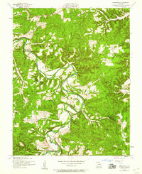
1954 Map of Brownfield
USGS Topo · Published 1959About this map
The Gasconade River carves a deeply winding path through this portion of the Mark Twain National Forest, marking the boundary between Pulaski County and Laclede County. In the mid-1950s, the small settlement of Brownfield served as a local hub, supported by the Brownfield School and two houses of worship, the Brownfield Missionary Church and the nearby Fairview Church. The map reveals a landscape of dispersed family homesteads and upland farming communities, indicated by numerous family burial grounds such as Rollins Cem, Nicks Cem, and Stepson Cem. On the eastern edge, the terrain transitions toward the Fort Leonard Wood Military Reservation, while the high ground near the Fairview community is anchored by the Fairview Lookout Tower. Numerous hollows like Killman Hollow and Flatrock Hollow drain into the river and its tributaries, including Roubidoux Creek, illustrating the complex drainage patterns of the Ozark Plateau.
Find a feature on this map
29 named features on this map. Tap any name to fly to it.
Don’t see what you’re looking for? This feature index may not catch every label — zoom into the map to look around manually.
Map Details
Editions of this 1954 Brownfield Map
2 editions found
Other maps of this area

1936 · Waynesville
USGS Topo · 1:48,000

1941 · Big Piney
USGS Topo · 1:62,500

1942 · Waynesville
USGS Topo · 1:62,500

1943 · Richland
USGS Topo · 1:62,500

1943 · Big Piney
USGS Topo · 1:62,500

1943 · Drynob
USGS Topo · 1:62,500

1944 · Waynesville
USGS Topo · 1:62,500

1954 · Springfield
USGS Topo · 1:250,000

1954 · Drynob
USGS Topo · 1:62,500
1954 · Big Piney
USGS Topo · 1:62,500