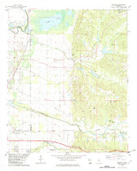
1982 Map of Browning
USGS Topo · Published 1982About this map
The Leflore Co Carroll Co line runs through a landscape defined by the transition from the Mississippi Delta to the Loess Hills. Near the southern edge of the survey, Malmaison stands as a notable landmark, once the site of the home of Choctaw chief Greenwood LeFlore, whose legacy is further marked at the Greenwood LeFlore Cem. The terrain is deeply etched by a complex drainage system including Teoc Creek, Puchshinubie Creek, and Big Sand Creek, which flow toward the Yalobusha River and Sharkey Bayou in the northwest. Communities such as Valley Hill, Browning, and Crenfree are connected by a network of rural roads and the Columbus and Greenville route. Religious and social centers are frequent, from Mitchell Springs Ch to Cypress Grove Ch, indicating a persistent rural settlement pattern amidst the dissected hill country.
Find a feature on this map
46 named features on this map. Tap any name to fly to it.
Don’t see what you’re looking for? This feature index may not catch every label — zoom into the map to look around manually.
Map Details
Editions of this 1982 Browning Map
This is the sole edition of this map. No revisions or reprints were ever made.
Other maps of this area

1936 · Greenwood
USGS Topo · 1:62,500

1940 · Seven Pines
USGS Topo · 1:62,500

1940 · Greenwood
USGS Topo · 1:62,500

1953 · Greenwood
USGS Topo · 1:250,000

1953 · West Point
USGS Topo · 1:250,000

1954 · McCarley
USGS Topo · 1:62,500

1956 · Greenwood
USGS Topo · 1:250,000

1957 · Greenwood
USGS Topo · 1:62,500

1957 · Seven Pines
USGS Topo · 1:62,500

1958 · West Point
USGS Topo · 1:250,000