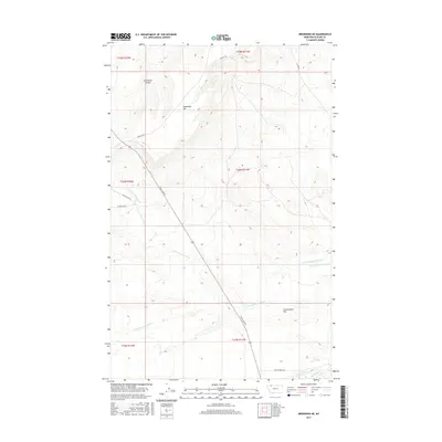
2017 Map of Browning NE
USGS Topo · Published 2017About this map
Houseman Hill and the broad expanse of Greasewood Flat dominate this section of the northern plains within Glacier County. The landscape is defined by the drainage systems of the N Fork Greasewood Cr and S Fork Greasewood Cr, which carve through the high prairie before reaching Cut Bank Cr at the southern edge of the sheet. This terrain, characterized by features like Sand Rock Coulee, reflects the open, unpopulated character of the Montana ranching country in the early twenty-first century. A network of rural routes, including the long stretch of Duck Lake Rd and the Arnoux Trl, provides the primary access through these sections. Named local roads such as Mc Allister Rd, Le Mieux Rd, and Yellow Wolf Rd highlight family names and local history connected to the land use in this part of the state.
Find a feature on this map
18 named features on this map. Tap any name to fly to it.
Don’t see what you’re looking for? This feature index may not catch every label — zoom into the map to look around manually.
Map Details
Editions of this 2017 Browning NE Map
This is the sole edition of this map. No revisions or reprints were ever made.
Other maps of this area

1901 · Browning
USGS Topo · 1:125,000

1903 · Browning
USGS Topo · 1:125,000

1911 · Blackfoot
USGS Topo · 1:125,000

1960 · Cut Bank
USGS Topo · 1:250,000

1963 · Cut Bank
USGS Topo · 1:250,000

1964 · Cut Bank
USGS Topo · 1:250,000

1968 · Hoodoo Hill
USGS Topo · 1:24,000

1968 · Browning NE
USGS Topo · 1:24,000
1968 · Browning
USGS Topo · 1:24,000
1968 · Starr School
USGS Topo · 1:24,000