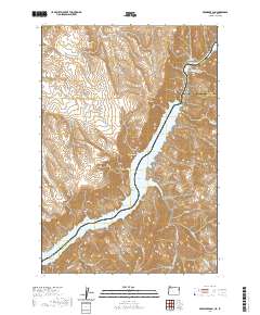
2020 Map of Brownlee Dam
USGS Topo · Published 2020About this map
Brownlee Dam anchors this stretch of the Snake River canyon, where the border between Baker County, Oregon, and Washington and Adams Counties, Idaho, is defined by the deep waters of Brownlee Reservoir. The settlement of Brownlee sits on the western shore, positioned near a landscape marked by steep drainage patterns and notable elevations such as Officer Butte and Road Mtn. Historical crossing points and river navigation are suggested by features like Ferry Canyon and the Wildhorse Rapids located near the confluence of the Wildhorse River. The terrain is deeply dissected by numerous watercourses, including Brownlee Cr and Flat Cr, which cut through the high ridges of Black Canyon and Board Gulch. This contemporary survey reflects the modern infrastructure of the Snake River, illustrating the massive scale of water management and its effect on the local topography.
Find a feature on this map
37 named features on this map. Tap any name to fly to it.
Don’t see what you’re looking for? This feature index may not catch every label — zoom into the map to look around manually.
Map Details
Editions of this 2020 Brownlee Dam Map
This is the sole edition of this map. No revisions or reprints were ever made.
Other maps of this area

1915 · Pine
USGS Topo · 1:125,000

1955 · Baker
USGS Topo · 1:250,000

1957 · Halfway
USGS Topo · 1:62,500

1957 · Copperfield
USGS Topo · 1:62,500

1957 · Sturgill Peak
USGS Topo · 1:62,500

1957 · Mineral
USGS Topo · 1:62,500

1959 · Baker
USGS Topo · 1:250,000

1980 · McCall
USGS Topo · 1:100,000

1981 · Baker
USGS Topo · 1:100,000
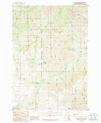
1987 · Mc Lain Gulch
USGS Topo · 1:24,000