
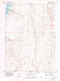
1978 Map of Browns Bench North
USGS Topo · Published 1978About this map
High-desert ranching and water resources define this landscape on the Browns Bench plateau in the late 1970s. The map illustrates a reliance on scattered water sources across a network of canyons, with individual sites like the Antelope Spring Ranch, Vosburg Place, and Rock House Place marking the primary points of settlement. The presence of a Grave near the Rock House Place and the Indian Cave to the southeast provides a glimpse into the local history and previous habitation of this arid region.
Find a feature on this map
33 named features on this map. Tap any name to fly to it.
Don’t see what you’re looking for? This feature index may not catch every label — zoom into the map to look around manually.
Map Details
Editions of this 1978 Browns Bench North Map
This is the sole edition of this map. No revisions or reprints were ever made.
Other maps of this area

1955 · Twin Falls
USGS Topo · 1:250,000

1958 · Twin Falls
USGS Topo · 1:250,000

1964 · Roseworth
USGS Topo · 1:24,000

1965 · Hollister SW
USGS Topo · 1:24,000

1965 · Roseworth SE
USGS Topo · 1:24,000

1977 · Browns Bench South
USGS Topo · 1:24,000

1977 · Cedar Creek Reservoir
USGS Topo · 1:24,000

1977 · Salmon Butte
USGS Topo · 1:24,000

1978 · Taylor Canyon
USGS Topo · 1:24,000
1978 · Meteor
USGS Topo · 1:24,000