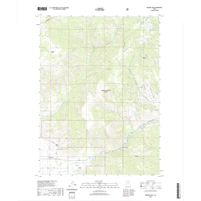
2020 Map of Browns Hole
USGS Topo · Published 2020About this map
Cache National Forest encompasses the high country of the Wasatch Range in this 2020 map, where steep canyons and sharp ridges define the landscape of eastern Weber County. The complex drainage network of the Middle Fork Ogden River and its various tributaries, including Cobble Cr and Elk Cr, dominate the central terrain. High-altitude depressions like Browns Hole and Jorgensen Hollow reflect the geographic variety of the forest land.
Find a feature on this map
43 named features on this map. Tap any name to fly to it.
Don’t see what you’re looking for? This feature index may not catch every label — zoom into the map to look around manually.
Map Details
Editions of this 2020 Browns Hole Map
This is the sole edition of this map. No revisions or reprints were ever made.
Other maps of this area

1954 · Ogden
USGS Topo · 1:250,000

1955 · Huntsville
USGS Topo · 1:24,000

1955 · James Peak
USGS Topo · 1:24,000

1955 · Snow Basin
USGS Topo · 1:24,000

1958 · Ogden
USGS Topo · 1:250,000

1960 · Ogden
USGS Topo · 1:250,000

1961 · Morgan
USGS Topo · 1:62,500

1964 · Monte Cristo PK
USGS Topo · 1:24,000
1964 · Sharp Mountain
USGS Topo · 1:24,000
1964 · Browns Hole
USGS Topo · 1:24,000
Featured Places
- Green Hill Country Estates, UT
- Huntsville Hollow, UT
- Evergreen Park, UT
- Mountain Valley Meadows, UT
- Weber County, UT