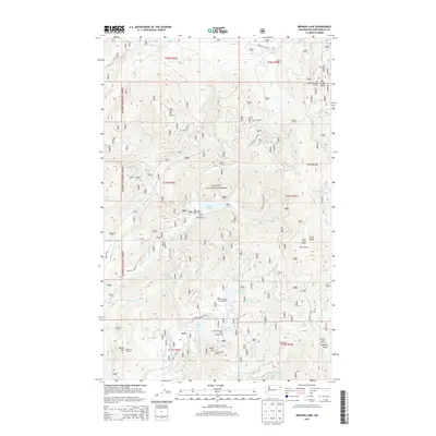
2014 Map of Browns Lake
USGS Topo · Published 2014About this map
Kanisku National Forest encompasses this high-elevation landscape in Pend Oreille County, defined by a dense network of mountain lookouts and secluded lakes. The 2014 survey reveals a territory managed for both recreation and fire watch, with several active or historic observation points including Mill Creek Lookout, South Baldy Lookout, Kings Mountain Lookout, and Moon Hill Lookout. These peaks overlook a series of glacial lakes that serve as focal points for backcountry access. Browns Lake, Half Moon Lake, and Kings Lake are interconnected by a system of forest development roads, including Browns Creek Rd and Boswell-Kings Lake Rd. Public access is concentrated at sites like the Browns Lake Campground and South Skookum Lake Campground, while the surrounding terrain rises to prominent heights at Cee Cee Ah Peak and along the Pelke Divide.
Find a feature on this map
47 named features on this map. Tap any name to fly to it.
Don’t see what you’re looking for? This feature index may not catch every label — zoom into the map to look around manually.
Map Details
Editions of this 2014 Browns Lake Map
This is the sole edition of this map. No revisions or reprints were ever made.
Other maps of this area

1934 · Metaline
USGS Topo · 1:125,000

1936 · Newport
USGS Topo · 1:96,000

1942 · Metaline
USGS Topo · 1:125,000

1942 · Newport
USGS Topo · 1:125,000

1958 · Sandpoint
USGS Topo · 1:250,000

1963 · Sandpoint
USGS Topo · 1:250,000
1967 · North Baldy
USGS Topo · 1:24,000
1967 · Gleason Mtn
USGS Topo · 1:24,000
1967 · Ruby
USGS Topo · 1:24,000

1968 · Cusick
USGS Topo · 1:24,000