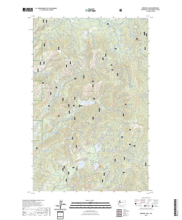
2023 Map of Browns Lake
USGS Topo · Published 2023About this map
Kaniksu National Forest defines this high-elevation landscape in Pend Oreille County, characterized by a complex system of glacial lakes and mountain ridges. The drainage patterns of the Pelke Divide and peaks like Cee Cee Ah Peak and Kings Mtn feed numerous water bodies, including the secluded Browns Lake, which is accessible via the Browns Lake Trl. This area is a critical watershed where the North Fork Skookum Creek and South Skookum Lake provide a stark contrast to the surrounding steep terrain.
Find a feature on this map
34 named features on this map. Tap any name to fly to it.
Don’t see what you’re looking for? This feature index may not catch every label — zoom into the map to look around manually.
Map Details
Editions of this 2023 Browns Lake Map
This is the sole edition of this map. No revisions or reprints were ever made.
Other maps of this area

1934 · Metaline
USGS Topo · 1:125,000

1936 · Newport
USGS Topo · 1:96,000

1942 · Metaline
USGS Topo · 1:125,000

1942 · Newport
USGS Topo · 1:125,000

1958 · Sandpoint
USGS Topo · 1:250,000

1963 · Sandpoint
USGS Topo · 1:250,000
1967 · North Baldy
USGS Topo · 1:24,000
1967 · Gleason Mtn
USGS Topo · 1:24,000
1967 · Ruby
USGS Topo · 1:24,000

1968 · Cusick
USGS Topo · 1:24,000