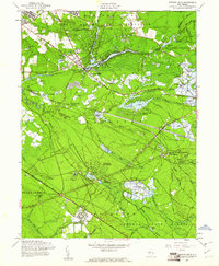
1957 Map of Browns Mills
USGS Topo · Published 1961About this map
Hanover Furnace and the agricultural hub of Whitesbog anchor this mid-century view of the New Jersey Pine Barrens. The landscape is defined by the heavy footprint of the Fort Dix Military Reservation to the north and the sprawling Lebanon State Forest to the south. Numerous cranberry bogs are etched into the terrain along the Rancocas Creek North Branch and Pole Bridge Branch, highlighting the region's specialized wetland industry. Settlement patterns are concentrated around Browns Mills and the Mirror Lake area, while the Pennsylvania Railroad cuts a diagonal path through the woods toward Upton. Institutional presence is notable at the Deborah Sanatorium and the State Hospital near Four Mile, reflecting the era's use of these secluded, forested environments for medical and state facilities. Sand roads and fire breaks crisscross the dense woods, leading to localized landmarks like Mount Misery and Pakim Pond.
Find a feature on this map
69 named features on this map. Tap any name to fly to it.
Don’t see what you’re looking for? This feature index may not catch every label — zoom into the map to look around manually.
Map Details
Editions of this 1957 Browns Mills Map
4 editions found
Other maps of this area

1884 · Whitings
USGS Topo · 1:62,500

1888 · Bordentown
USGS Topo · 1:62,500

1888 · Pemberton
USGS Topo · 1:62,500

1888 · Cassville
USGS Topo · 1:62,500

1888 · Whitings
USGS Topo · 1:62,500

1893 · Bordentown
USGS Topo · 1:62,500

1894 · Cassville
USGS Topo · 1:62,500

1894 · Pemberton
USGS Topo · 1:62,500

1898 · Pemberton
USGS Topo · 1:62,500

1900 · Cassville
USGS Topo · 1:62,500
Featured Places
- Southampton Township, NJ
- Plumsted Township, NJ
- Wrightstown, NJ
- New Hanover Township, NJ
- Pemberton Township, NJ