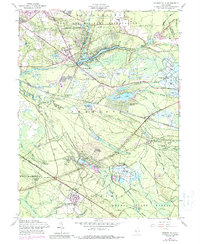
1957 Map of Browns Mills
USGS Topo · Published 1988About this map
Mirror Lake and the surrounding Pemberton landscape define this mid-century view of the New Jersey Pine Barrens. The settlement of Browns Mills serves as a hub, bordered by the expansive Fort Dix Military Reservation to the north and the dense woodlands of Lebanon State Forest to the south. This era is characterized by a specialized agricultural and industrial landscape, clearly visible through the numerous cranberry bogs lining North Branch Rancocas Creek and Pole Bridge Branch. Significant institutions and historic industrial sites are noted throughout the area, including the Deborah Sanatorium, the early industrial center at Hanover Furnace, and the specialized berry-growing community of Whitesbog. Transportation patterns of the late 1950s are preserved via the Penn Central railroad and local intersections like Four Mile Circle and Browns Mills Junction. Remote outposts such as Ongs Hat and Mount Misery offer a glimpse into the localized geography of the Pinelands before modern suburban expansion.
Find a feature on this map
71 named features on this map. Tap any name to fly to it.
Don’t see what you’re looking for? This feature index may not catch every label — zoom into the map to look around manually.
Map Details
Editions of this 1957 Browns Mills Map
4 editions found
Other maps of this area

1884 · Whitings
USGS Topo · 1:62,500

1888 · Bordentown
USGS Topo · 1:62,500

1888 · Pemberton
USGS Topo · 1:62,500

1888 · Cassville
USGS Topo · 1:62,500

1888 · Whitings
USGS Topo · 1:62,500

1893 · Bordentown
USGS Topo · 1:62,500

1894 · Cassville
USGS Topo · 1:62,500

1894 · Pemberton
USGS Topo · 1:62,500

1898 · Pemberton
USGS Topo · 1:62,500

1900 · Cassville
USGS Topo · 1:62,500
Featured Places
- Southampton Township, NJ
- Plumsted Township, NJ
- Wrightstown, NJ
- New Hanover Township, NJ
- Pemberton Township, NJ