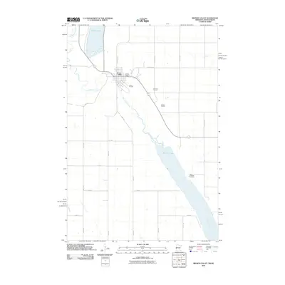
2010 Map of Browns Valley
USGS Topo · Published 2010About this map
Browns Valley serves as the focal point of this 2010 survey, positioned at the critical hydrological divide between Lake Traverse and Big Stone Lake. This unique geography marks the headwaters of two major continental drainage systems: the Little Minnesota River flows southeast into the Minnesota River toward the Gulf of Mexico, while just to the north, water begins its journey toward Hudson Bay. The map illustrates a landscape of managed agriculture and local infrastructure, featuring the Browns Valley Post Office and Bullock Airport. Notable for local history and genealogy, the sheet identifies Plateau Cemetery and Valley View Cemetery on the outskirts of the settlement. The presence of the Holtz Irrigation Pond Dam reflects the ongoing importance of water management in this prairie borderland where the Minnesota and South Dakota state lines meet.
Find a feature on this map
24 named features on this map. Tap any name to fly to it.
Don’t see what you’re looking for? This feature index may not catch every label — zoom into the map to look around manually.
Map Details
Editions of this 2010 Browns Valley Map
This is the sole edition of this map. No revisions or reprints were ever made.
Other maps of this area

1916 · Peever
USGS Topo · 1:62,500

1916 · Beardsley
USGS Topo · 1:62,500

1918 · Peever
USGS Topo · 1:62,500

1918 · Beardsley
USGS Topo · 1:62,500

1953 · Milbank
USGS Topo · 1:250,000

1954 · Big Stone Lake
USGS Topo · 1:62,500

1958 · Milbank
USGS Topo · 1:250,000

1970 · Wilmot NW
USGS Topo · 1:24,000

1971 · Browns Valley
USGS Topo · 1:24,000
1971 · Peever
USGS Topo · 1:24,000
Featured Places
- Browns Valley, MN
- Lake Traverse District, SD
- Traverse County, MN
- Roberts County, SD
- Big Stone County, MN