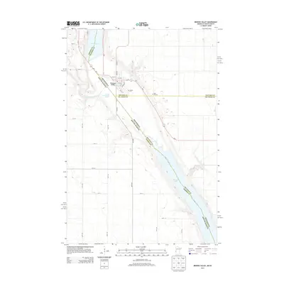
2013 Map of Browns Valley
USGS Topo · Published 2013About this map
Browns Valley sits at a geographic pivot point where the continental divide separates waters flowing north to the Arctic and south to the Gulf. This 2013 survey details the town's position within the Ancient River Warren Channel, a massive prehistoric glacial valley that now contains Lake Traverse and Big Stone Lake. The landscape is defined by this broad valley floor, where the Little Minnesota River and Minnesota River transition through the marshy lowlands. Local history is recorded at sites like Plateau Cem on the valley's edge and Valley View Cem to the east. The map clearly illustrates the interstate boundary between Minnesota and South Dakota, which follows the centerline of the river and lakes through this distinct geological corridor.
Find a feature on this map
34 named features on this map. Tap any name to fly to it.
Don’t see what you’re looking for? This feature index may not catch every label — zoom into the map to look around manually.
Map Details
Editions of this 2013 Browns Valley Map
This is the sole edition of this map. No revisions or reprints were ever made.
Other maps of this area

1916 · Peever
USGS Topo · 1:62,500

1916 · Beardsley
USGS Topo · 1:62,500

1918 · Peever
USGS Topo · 1:62,500

1918 · Beardsley
USGS Topo · 1:62,500

1953 · Milbank
USGS Topo · 1:250,000

1954 · Big Stone Lake
USGS Topo · 1:62,500

1958 · Milbank
USGS Topo · 1:250,000

1970 · Wilmot NW
USGS Topo · 1:24,000

1971 · Browns Valley
USGS Topo · 1:24,000
1971 · Peever
USGS Topo · 1:24,000
Featured Places
- Browns Valley, MN
- Lake Traverse District, SD
- Traverse County, MN
- Roberts County, SD
- Big Stone County, MN