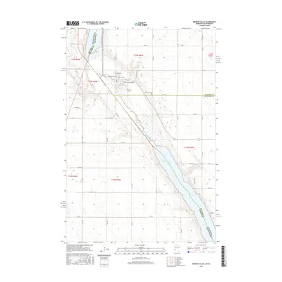
2016 Map of Browns Valley
USGS Topo · Published 2016About this map
Browns Valley sits at the narrow land bridge between two major bodies of water, serving as a focal point for the border region of Minnesota and South Dakota. This topographic study reveals the town's position at the northern head of Big Stone Lake and the southern reach of Lake Traverse, where the continental divide separates water flowing north to Hudson Bay from water flowing south to the Gulf of Mexico. The Little Minnesota River winds through the valley floor, south of the main settlement and north of the Traverse and Big Stone county line. On the outskirts of town, local history is preserved at Plateau Cem and Valley View Cem, which overlook the surrounding valley floor. The map highlights the intersection of regional routes like Co Hwy 2 and Co Rd 52, illustrating the transport network connecting these lakeside communities.
Find a feature on this map
50 named features on this map. Tap any name to fly to it.
Don’t see what you’re looking for? This feature index may not catch every label — zoom into the map to look around manually.
Map Details
Editions of this 2016 Browns Valley Map
This is the sole edition of this map. No revisions or reprints were ever made.
Other maps of this area

1916 · Peever
USGS Topo · 1:62,500

1916 · Beardsley
USGS Topo · 1:62,500

1918 · Peever
USGS Topo · 1:62,500

1918 · Beardsley
USGS Topo · 1:62,500

1953 · Milbank
USGS Topo · 1:250,000

1954 · Big Stone Lake
USGS Topo · 1:62,500

1958 · Milbank
USGS Topo · 1:250,000

1970 · Wilmot NW
USGS Topo · 1:24,000

1971 · Browns Valley
USGS Topo · 1:24,000
1971 · Peever
USGS Topo · 1:24,000
Featured Places
- Browns Valley, MN
- Lake Traverse District, SD
- Traverse County, MN
- Roberts County, SD
- Big Stone County, MN