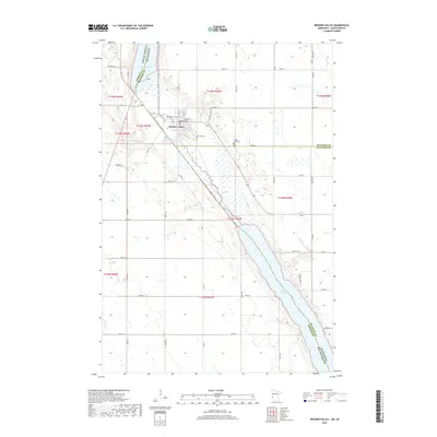
2019 Map of Browns Valley
USGS Topo · Published 2019About this map
Browns Valley sits at a geographic pivot point where the continental divide separates waters flowing north toward the Hudson Bay from those moving south to the Gulf of Mexico. This landscape is defined by the Ancient River Warren Channel, a massive prehistoric glacial outlet that now contains the headwaters of the Little Minnesota River. The map details the precise corridor between Lake Traverse and Big Stone Lake, a narrow land bridge that served as a critical portage for early travelers and traders. Within the town site, the residential grid is anchored by Broadway and surrounded by local landmarks including Plateau Cem and Valley View Cem. The survey clearly delineates the tri-county intersection of Traverse, Big Stone, and Roberts counties, marking the jurisdictional borders that meet in this unique glacial valley.
Find a feature on this map
46 named features on this map. Tap any name to fly to it.
Don’t see what you’re looking for? This feature index may not catch every label — zoom into the map to look around manually.
Map Details
Editions of this 2019 Browns Valley Map
This is the sole edition of this map. No revisions or reprints were ever made.
Other maps of this area

1916 · Peever
USGS Topo · 1:62,500

1916 · Beardsley
USGS Topo · 1:62,500

1918 · Peever
USGS Topo · 1:62,500

1918 · Beardsley
USGS Topo · 1:62,500

1953 · Milbank
USGS Topo · 1:250,000

1954 · Big Stone Lake
USGS Topo · 1:62,500

1958 · Milbank
USGS Topo · 1:250,000

1970 · Wilmot NW
USGS Topo · 1:24,000

1971 · Browns Valley
USGS Topo · 1:24,000
1971 · Peever
USGS Topo · 1:24,000
Featured Places
- Browns Valley, MN
- Lake Traverse District, SD
- Traverse County, MN
- Roberts County, SD
- Big Stone County, MN