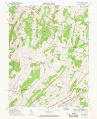
1967 Map of Brownsburg
USGS Topo · Published 1969About this map
Hays Creek and Moffatts Creek carve through the landscape of the Shenandoah Valley, defining a region where agricultural industry and early settlements concentrated along reliable water power. This mid-century survey captures the community of Brownsburg and surrounding rural hubs like Fairfield and Jonestown before significant modern development altered the local character. The map is particularly rich in local genealogy markers, showing the locations of several houses of worship and burial grounds, including New Providence Ch and the McElwee Chapel Cem. Industrial heritage is preserved through the labeling of Wades Mill and McClung Mill, which served the local farming economy. An old railroad grade and an old RR grade trace former transportation corridors through the valley floor, while a prominent Pipeline indicates the arrival of modern infrastructure during this era of Commonwealth development overseen by James L. Calver.
Find a feature on this map
48 named features on this map. Tap any name to fly to it.
Don’t see what you’re looking for? This feature index may not catch every label — zoom into the map to look around manually.
Map Details
Editions of this 1967 Brownsburg Map
2 editions found
Other maps of this area

1894 · Staunton
USGS Topo · 1:125,000

1894 · Lexington
USGS Topo · 1:125,000

1932 · Lexington
USGS Topo · 1:48,000

1936 · Vesuvius
USGS Topo · 1:48,000

1937 · Lexington
USGS Topo · 1:62,500

1941 · Vesuvius
USGS Topo · 1:62,500

1943 · Craigsville
USGS Topo · 1:62,500

1944 · Staunton
USGS Topo · 1:62,500

1945 · Craigsville
USGS Topo · 1:62,500

1947 · Staunton
USGS Topo · 1:62,500