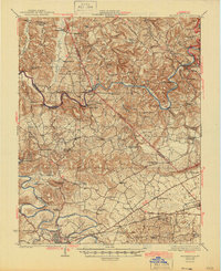
1923 Map of Brownsville
USGS Topo · Published 1946About this map
Green River and Barren River dominate this Central Kentucky landscape, their winding courses dictating the commerce and movement of the early 1920s. This survey, conducted by C. W. Goodlove and colleagues, illustrates a river-dependent economy where crossings like Drakers Ferry, Young Ferry, and Parrish Mill Ferry were essential infrastructure before modern bridges. The terrain is densely populated with community landmarks, including the Bethlehem Church and dozens of rural schoolhouses such as Chalybeate School and Mt Zion School. To the south, the Louisville and Nashville RR serves as a vital artery through Bristow and Bowling Green, while the northern portion of the sheet highlights the intricate drainage of Little Reedy Creek and Bear Creek. The map provides a clear look at the early 20th-century road network, including the Morgantown Road, as it connects smaller settlements like Round Hill and Reedyville.
Find a feature on this map
91 named features on this map. Tap any name to fly to it.
Don’t see what you’re looking for? This feature index may not catch every label — zoom into the map to look around manually.
Map Details
Editions of this 1923 Brownsville Map
3 editions found
Other maps of this area

1914 · Little Muddy
USGS Topo · 1:62,500

1921 · Bowling Green
USGS Topo · 1:62,500

1922 · Leitchfield
USGS Topo · 1:48,000

1922 · Brownsville
USGS Topo · 1:62,500

1922 · Mammoth Cave
USGS Topo · 1:62,500

1923 · Bowling Green
USGS Topo · 1:62,500

1923 · Mammoth Cave
USGS Topo · 1:62,500

1923 · Brownsville
USGS Topo · 1:62,500

1925 · Spring Lick
USGS Topo · 1:62,500

1925 · Cub Run
USGS Topo · 1:62,500