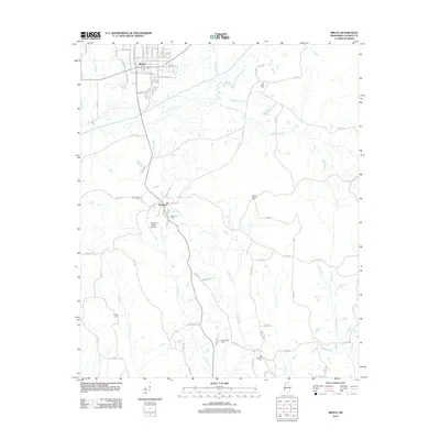
2012 Map of Bruce
USGS Topo · Published 2012About this map
Bruce and Pittsboro anchor this northern Mississippi landscape, where the street grid of Bruce follows the path of Railroad St and the banks of the Skuna River. The river system defines the local geography, with numerous tributaries such as Thompsons Cr, Hurricane Cr, and Huffman Cr carving through the terrain. For those tracing local history, several family and community landmarks are identified, including Old Town Cem near the northern boundary and Macedonia Cem to the south. The Calhoun County Airport is situated just south of the creek-side settlement at Pittsboro, reflecting the area's mid-century modernization. The map's layout highlights the transition from the organized municipal blocks of W Clay St and E Countiss St to the winding county roads that connect outlying sites like Gaston Springs Cem.
Find a feature on this map
92 named features on this map. Tap any name to fly to it.
Don’t see what you’re looking for? This feature index may not catch every label — zoom into the map to look around manually.
Map Details
Editions of this 2012 Bruce Map
This is the sole edition of this map. No revisions or reprints were ever made.
Other maps of this area

1953 · West Point
USGS Topo · 1:250,000

1954 · Pittsboro
USGS Topo · 1:62,500

1956 · Tupelo
USGS Topo · 1:250,000

1958 · Tupelo
USGS Topo · 1:250,000

1958 · West Point
USGS Topo · 1:250,000

1963 · West Point
USGS Topo · 1:250,000

1972 · Robbs
USGS Topo · 1:24,000

1972 · Atlanta
USGS Topo · 1:24,000
1972 · Banner
USGS Topo · 1:24,000

1972 · Vardaman
USGS Topo · 1:24,000