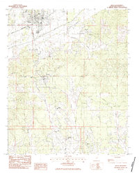
1983 Map of Bruce
USGS Topo · Published 1984About this map
The Mississippi and Skuna Valley railroad cuts across the northern landscape of this 1980s Calhoun County survey, connecting the timber and agricultural lands near Bruce to the broader regional economy. The Skuna River basin dominates the terrain, with the Skuna River winding through a broad valley floor flanked by numerous tributaries like Hurricane Creek and Twin Creek. While Bruce serves as a primary center of activity, the smaller settlement of Pittsboro remains a vital community hub further south, anchored by local institutions like Calhoun Academy.
Find a feature on this map
35 named features on this map. Tap any name to fly to it.
Don’t see what you’re looking for? This feature index may not catch every label — zoom into the map to look around manually.
Map Details
Editions of this 1983 Bruce Map
This is the sole edition of this map. No revisions or reprints were ever made.
Other maps of this area

1953 · West Point
USGS Topo · 1:250,000

1954 · Pittsboro
USGS Topo · 1:62,500

1956 · Tupelo
USGS Topo · 1:250,000

1958 · Tupelo
USGS Topo · 1:250,000

1958 · West Point
USGS Topo · 1:250,000

1963 · West Point
USGS Topo · 1:250,000

1972 · Robbs
USGS Topo · 1:24,000

1972 · Atlanta
USGS Topo · 1:24,000
1972 · Banner
USGS Topo · 1:24,000

1972 · Vardaman
USGS Topo · 1:24,000