
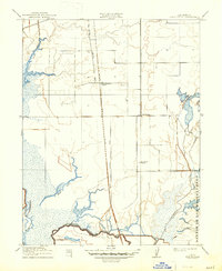
1910 Map of Bruceville
USGS Topo · Published 1910About this map
Bruceville stands at the heart of this 1910 landscape, situated between the intricate wetlands of the Central Valley and the developing agricultural corridor south of Sacramento. This era marks a significant period of transit and water management, evidenced by the Sacramento Drainage Canal and the parallel tracks of the Lower Stockton Road and Western Pacific Road. The map reveals the vital role of local education and industry in early twentieth-century rural California, with the Point Pleasant School and the Bradford Winery serving as key community anchors.
Find a feature on this map
15 named features on this map. Tap any name to fly to it.
Don’t see what you’re looking for? This feature index may not catch every label — zoom into the map to look around manually.
Map Details
Editions of this 1910 Bruceville Map
2 editions found
Other maps of this area

1894 · Lodi
USGS Topo · 1:125,000

1908 · Courtland
USGS Topo · 1:62,500

1909 · Elk Grove
USGS Topo · 1:31,680

1909 · Florin
USGS Topo · 1:31,680

1910 · New Hope
USGS Topo · 1:31,680

1910 · Woodbridge
USGS Topo · 1:31,680

1910 · Galt
USGS Topo · 1:31,680

1910 · Isleton
USGS Topo · 1:31,680

1916 · Vorden
USGS Topo · 1:31,680
1916 · Babel Slough
USGS Topo · 1:31,680