
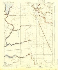
1910 Map of New Hope
USGS Topo · Published 1910About this map
The low-lying Delta lands at the junction of Sacramento and San Joaquin counties are defined here by an intricate web of sloughs and river channels. The Mokelumne River and its South Fork carve through the terrain, isolating large tracts like Staten Island and Deadhorse Island. This landscape, surveyed in 1907-1908, reveals an early twentieth-century reliance on both water and rail transport. While the Western Pacific railroad cuts a straight line across the eastern marshes, established landings such as New Hope Landing indicate the ongoing importance of riverine commerce. The presence of the New Hope School and the small station at Taison suggest a dispersed but settled agricultural community. Tracing the Sanjon de los Moquelumnes boundary line provides a view into the historic land divisions and drainage patterns essential for the development of this reclaimed California territory.
Find a feature on this map
19 named features on this map. Tap any name to fly to it.
Don’t see what you’re looking for? This feature index may not catch every label — zoom into the map to look around manually.
Map Details
Editions of this 1910 New Hope Map
2 editions found
Other maps of this area

1894 · Lodi
USGS Topo · 1:125,000

1908 · Courtland
USGS Topo · 1:62,500

1910 · Castle
USGS Topo · 1:31,680

1910 · Bouldin
USGS Topo · 1:31,680

1910 · Woodbridge
USGS Topo · 1:31,680

1910 · Bruceville
USGS Topo · 1:31,680

1910 · Headreach
USGS Topo · 1:31,680

1910 · Galt
USGS Topo · 1:31,680

1910 · Isleton
USGS Topo · 1:31,680

1916 · Vorden
USGS Topo · 1:31,680