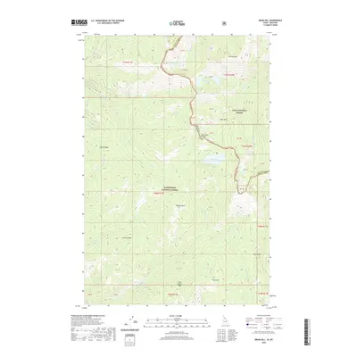
2020 Map of Bruin Hill
USGS Topo · Published 2020About this map
The Bitterroot Range defines the high-altitude divide between Idaho and Montana on this 2020 survey, where the Lolo National Forest meets the Clearwater National Forest. This remote corridor is characterized by dramatic ridges and alpine hydrology, featuring notable summits like Bruin Hill and the prominent Wapito Point. The map provides a detailed look at the drainage patterns of the region, including the headwaters of W Fork Fish Cr and the string of basins containing Siamese Lakes, Steep Lakes, and Fish Lake. For those interested in the historical passage across the mountains, the map identifies Chilcoot Pass and various topographic features such as Pollock Ridge and Swamp Ridge that have long dictated movement through this wilderness area. The survey clearly delineates the border between Mineral County and Clearwater County, showing the intersection of state lines and public land boundaries.
Find a feature on this map
40 named features on this map. Tap any name to fly to it.
Don’t see what you’re looking for? This feature index may not catch every label — zoom into the map to look around manually.
Map Details
Editions of this 2020 Bruin Hill Map
This is the sole edition of this map. No revisions or reprints were ever made.
Other maps of this area

1911 · Lolo
USGS Topo · 1:250,000

1913 · Lolo
USGS Topo · 1:250,000

1956 · Hamilton
USGS Topo · 1:250,000

1959 · Hamilton
USGS Topo · 1:250,000

1960 · Hamilton
USGS Topo · 1:250,000

1960 · Straight Peak
USGS Topo · 1:62,500

1964 · Hamilton
USGS Topo · 1:250,000
1965 · Hoodoo Pass
USGS Topo · 1:24,000

1965 · Osier Ridge
USGS Topo · 1:24,000

1965 · Gorman Hill
USGS Topo · 1:24,000