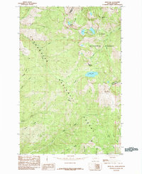
1985 Map of Bruin Hill
USGS Topo · Published 1985About this map
Bruin Hill rises as a prominent landmark within this high-elevation wilderness straddling the border between Idaho and Montana during the mid-1980s. This survey, located within the Clearwater National Forest and Lolo National Forest, documents a landscape defined by sharp ridges and glacial basins. Notable water features include Fish Lake, the twin Siamese Lakes, and Straight Lake. The intersection of Clearwater and Mineral counties follows the crest of the Bitterroot Range, with narrow trails navigating through Chilcoot Pass and into Foley Basin. A complex network of drainage systems, including Goose Creek, Pollock Creek, and Moose Creek, illustrates the hydrological pattern of these protected forest lands. The lack of modern road infrastructure highlights the primitive nature of the terrain, where place names like Wapito Point and Swamp Ridge designate the primary navigational markers for travelers.
Find a feature on this map
30 named features on this map. Tap any name to fly to it.
Don’t see what you’re looking for? This feature index may not catch every label — zoom into the map to look around manually.
Map Details
Editions of this 1985 Bruin Hill Map
This is the sole edition of this map. No revisions or reprints were ever made.
Other maps of this area

1911 · Lolo
USGS Topo · 1:250,000

1913 · Lolo
USGS Topo · 1:250,000

1956 · Hamilton
USGS Topo · 1:250,000

1959 · Hamilton
USGS Topo · 1:250,000

1960 · Hamilton
USGS Topo · 1:250,000

1960 · Straight Peak
USGS Topo · 1:62,500

1964 · Hamilton
USGS Topo · 1:250,000
1965 · Hoodoo Pass
USGS Topo · 1:24,000

1965 · Osier Ridge
USGS Topo · 1:24,000

1965 · Gorman Hill
USGS Topo · 1:24,000