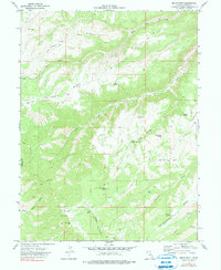
1972 Map of Bruin Point
USGS Topo · Published 1990About this map
Bruin Point stands as a prominent high point in this 1972 landscape of deep canyons and high plateaus within the South Ridge area. The presence of Mines and a cluster of Radio Towers at the summit suggests a mid-century shift toward industrial and communications activity in a territory otherwise defined by complex drainage systems and isolated springs. The terrain is marked by numerous Drill Holes, indicating a period of intensive subterranean exploration likely tied to the region's energy or mineral resources.
Find a feature on this map
29 named features on this map. Tap any name to fly to it.
Don’t see what you’re looking for? This feature index may not catch every label — zoom into the map to look around manually.
Map Details
Editions of this 1972 Bruin Point Map
2 editions found
Other maps of this area

1886 · Price River
USGS Topo · 1:250,000

1896 · Price River
USGS Topo · 1:250,000

1915 · Sunnyside
USGS Topo · 1:62,500

1954 · Flat Canyon
USGS Topo · 1:62,500

1956 · Price
USGS Topo · 1:250,000

1960 · Price
USGS Topo · 1:250,000

1962 · Price
USGS Topo · 1:250,000

1968 · Wood Canyon
USGS Topo · 1:24,000
1968 · Cowboy Bench
USGS Topo · 1:24,000
1968 · Currant Canyon
USGS Topo · 1:24,000