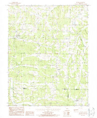
1987 Map of Brumley
USGS Topo · Published 1988About this map
Brumley and its surrounding rural communities are situated within a complex network of Ozark waterways and high ridges during the late 1980s. The landscape is defined by the convergence of several major drainages, including Tavern Creek, Brumley Creek, and Brushy Fork. Smaller settlements such as Keethtown, Samtown, and Rollins are spaced throughout the hills, often located near local creek crossings and fords. This map documents a time when the boundaries of Miller, Camden, and Pulaski counties met in a relatively undeveloped section of the state, where agriculture and topography dictated the placement of roads and homes. Prominent landforms like Shahan Ridge and Pemberton Ridge rise above the Mill Creek valley, while the label Glaze suggests a connection to the historic Glaze Township. Genealogists will find several unnamed Cem locations marked, providing clues to early family burial sites across these creek-fed valleys.
Find a feature on this map
22 named features on this map. Tap any name to fly to it.
Don’t see what you’re looking for? This feature index may not catch every label — zoom into the map to look around manually.
Map Details
Editions of this 1987 Brumley Map
This is the sole edition of this map. No revisions or reprints were ever made.
Other maps of this area

1888 · Versailles
USGS Topo · 1:125,000

1888 · Tuscumbia
USGS Topo · 1:125,000

1893 · Versailles
USGS Topo · 1:125,000

1894 · Tuscumbia
USGS Topo · 1:125,000

1932 · Versailles No 4
USGS Topo · 1:48,000

1933 · Stoutland
USGS Topo · 1:62,500

1933 · Iberia
USGS Topo · 1:62,500

1934 · Toronto
USGS Topo · 1:24,000

1934 · Bagnell
USGS Topo · 1:24,000

1937 · Iberia
USGS Topo · 1:62,500