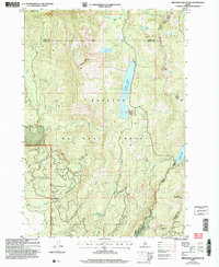
2004 Map of Brundage Mountain
USGS Topo · Published 2007About this map
Payette National Forest dominates this high-altitude terrain in the early 21st century, centered on the recreational and topographic prominence of Brundage Mountain. The landscape is defined by its water management and winter sports infrastructure, notably the Brundage Mtn Ski Area and the dual reservoirs of Goose Lake and Brundage Res. The map documents a complex network of drainage, where creeks like Threemile Creek and Fourmile Creek descend toward the Campbell Ditch. High peaks such as Granite Mtn, featuring a Lookout, and Slab Butte stand as major landmarks along the county boundaries of Adams and Valley counties. This edition reflects the transition from mid-century topographic surveys to modern forest management, preserving the nomenclature of early ranching and grazing like Corral Lake and Last Chance Spring.
Find a feature on this map
30 named features on this map. Tap any name to fly to it.
Don’t see what you’re looking for? This feature index may not catch every label — zoom into the map to look around manually.
Map Details
Editions of this 2004 Brundage Mountain Map
This is the sole edition of this map. No revisions or reprints were ever made.
Other maps of this area

1911 · Meadows
USGS Topo · 1:125,000

1938 · Riggins
USGS Topo · 1:96,000

1945 · Riggins
USGS Topo · 1:125,000

1954 · New Meadows
USGS Topo · 1:62,500

1955 · Baker
USGS Topo · 1:250,000

1955 · Grangeville
USGS Topo · 1:250,000

1959 · Baker
USGS Topo · 1:250,000

1959 · Grangeville
USGS Topo · 1:250,000

1963 · Bally Mountain
USGS Topo · 1:24,000

1963 · Indian Mountain
USGS Topo · 1:24,000