1946 Map of Bruneau Creek
USGS Topo · Published 1976About this map
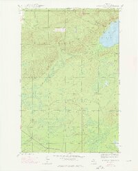
Mt Horace Greeley anchors the northern elevations of this Keweenaw Peninsula landscape, overlooking a complex drainage system that defines the local geography. The waters of Lake Gratiot dominate the northeastern shoreline, fed by mountain runoff through Fisher Creek and Nine Mile Creek. This 1946 survey, with revisions from 1975 aerial photography, reveals a wilderness partitioned by the boundary between Keweenaw County and Houghton County. To the south, the landscape transitions into a network of low-lying waterways including the Tobacco River and Traverse River, which wind through the township of Sherman. The mapping of Bruneau Creek and Snake Creek illustrates the intricate hydrological patterns of this Upper Michigan region, showing how the terrain funnels into the larger river systems that once supported the area's timber and mineral interests.
Find a feature on this map
13 named features on this map. Tap any name to fly to it.
Don’t see what you’re looking for? This feature index may not catch every label — zoom into the map to look around manually.
Map Details
Editions of this 1946 Bruneau Creek Map
3 editions found

Other maps of this area

1938 · Bruneau Creek
USGS Topo · 1:31,680

1938 · Gay
USGS Topo · 1:31,680

1938 · Delaware
USGS Topo · 1:31,680

1939 · Deer Lake
USGS Topo · 1:31,680

1939 · Delaware
USGS Topo · 1:31,680

1940 · Deer Lake
USGS Topo · 1:31,680

1940 · Central
USGS Topo · 1:31,680

1941 · Mohawk
USGS Topo · 1:31,680
1946 · Phoenix
USGS Topo · 1:24,000
1946 · Bruneau Creek
USGS Topo · 1:24,000
Featured Places
- Houghton Township, MI
- Eagle Harbor Township, MI
- Sherman Township, MI
- Gratiot Lake Beach, Eagle Harbor Township
- Keweenaw County, MI