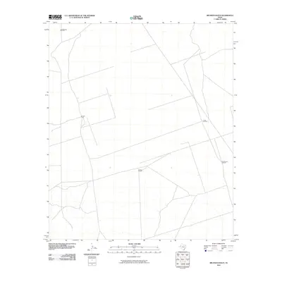
2010 Map of Brunson Ranch
USGS Topo · Published 2010About this map
Brunson Ranch serves as the primary landmark in this corner of West Texas, representing the sparse pastoral infrastructure of the Chihuahuan Desert landscape. The map shows a geography defined by the search for water, evidenced by a network of isolated pump sites such as Indian Springs Windmill and Lehman Windmill. These features, along with South Windmill and North Pipeline Windmill, illustrate the vital role of groundwater management in sustaining ranching operations in this arid environment during the early 21st century. The survey documents a series of unimproved roads and fence lines that connect these remote outposts, tracing the functional layout of a modern working ranch in Loving County.
Find a feature on this map
5 named features on this map. Tap any name to fly to it.
Don’t see what you’re looking for? This feature index may not catch every label — zoom into the map to look around manually.
Map Details
Editions of this 2010 Brunson Ranch Map
This is the sole edition of this map. No revisions or reprints were ever made.
Other maps of this area

1954 · Hobbs
USGS Topo · 1:250,000

1954 · Pecos
USGS Topo · 1:250,000

1957 · Pecos
USGS Topo · 1:250,000

1958 · Hobbs
USGS Topo · 1:250,000

1969 · Cheyenne Draw SW
USGS Topo · 1:24,000

1969 · Rudd Draw NE
USGS Topo · 1:24,000
1969 · Rudd Draw
USGS Topo · 1:24,000

1970 · Brunson Ranch
USGS Topo · 1:24,000

1970 · Cheyenne Draw
USGS Topo · 1:24,000

1970 · Cheyenne Draw SE
USGS Topo · 1:24,000